Aerial photograph collections
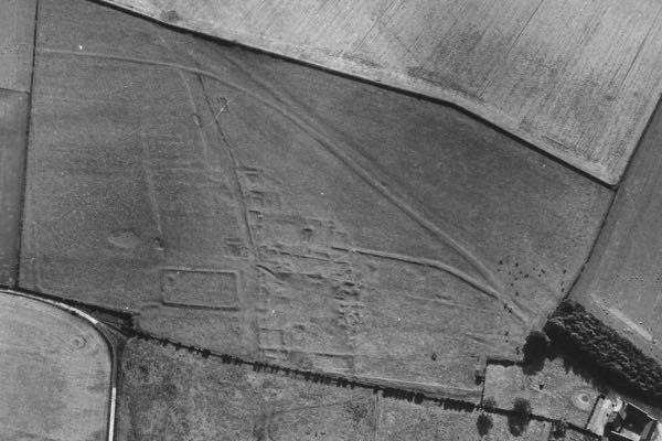
Argam medieval settlement, East Yorkshire.
A.L. Pacitto Collection, Ref: TP/140/13 21st July 1976
There are two aerial photograph collections held by the Yorkshire Archaeological and Historical Society (YAHS), the Derrick Riley Collection and A.L. Pacitto Collection. They contain over 6000 black and white, mainly oblique air photographs, taken during the 1970s and 80s. They are a valuable resource for studying Yorkshire landscapes and archaeological features captured within them.
The Aerial Archaeology Committee of the YAHS was formed in 1972 following a suggestion by Terry Manby. It established a group of locally based flyers and archaeologists, who collaborated to coordinate flights across Yorkshire, covering the historic county prior to 1974 boundary changes. Flying from local aerodromes and with knowledge of their areas had an advantage over previous long distance flights to Yorkshire undertaken by J.K. St Joseph from Cambridge (former Dept. of Aerial Photography at the University of Cambridge, CUCAP www.cambridgeairphotos.com)and John Hampton from London (former Air Photographs Unit of the RCHME, now within Historic England www.historicengland.org.uk/whats-new/research/50-years-flying/)
Derrick Riley (1915-1993) was an early pioneer of archaeological air photography and became Secretary of the Committee in 1976. The collection named after him, accrued through the Committee’s work is held within the Brotherton Library Special Collections (YAS/MS2013) along with other YAHS archives www.explore.library.leeds.ac.uk/special-collections-explore/471449
Anthony Laughton Pacitto (1931-2003), known to many as Tony, made frequent flights across Yorkshire, particulary North and East Yorkshire. His personal collection of air photos was acquired in 2004 by the Aerial Archaeology Committee, named the A.L. Pacitto Collection and some images can be viewed on an interactive map below.
Interactive Map of air photos
The interactive map, with the option of satellite background, provides an opportunity to explore the landscapes of Yorkshire. A selection of historical aerial photographs shows the diverse range of archaeological sites across the county from prehistory to the Second World War. Please note many sites illustrated here are on private land and not open to the public. You may save images for personal or educational use, copy to a blog or personal web page, but please acknowledge A.L. Pacitto Collection.